Abstract. Unmanned aerial systems (UAS, “drone”) technology has gained popularity in wildlife research. This study investigates whether environmental factors (time of day, water depth, sea floor substrate, glare) affect organism detectability in UAS surveys of green sea turtles. Videos of transects containing turtle decoys in Great Abaco, Bahamas were evaluated. Data regarding environmental factors was recorded. Additional drone-acquired data was obtained to evaluate glare. The results supported the hypothesis that environmental factors impact detectability of marine animals in drone-acquired surveys. These environmental variables are important to consider when interpreting data acquired by UAS in previous and ongoing ecological research.
Introduction. The green sea turtle, Chelonia mydas, is an endangered species of sea turtle which ranges worldwide in tropical and temperate seas, commonly found in areas rich in sea grass and algae, such as the Caribbean Sea. In every habitat in which they are found, every species of sea turtle is listed as threatened, and they are part of active conservation programs in many parts of the world (1). The primary threat to the survival of the green sea turtle is human activity. Chelonia mydas is hunted for its meat, and its eggs are harvested from beaches. Commercial fishing is also responsible for many turtle deaths every year. Some are killed by boat propellers, but many more are killed by drowning in fishing nets, trawls, traps, and long lines. This is called bycatch.
To support conservation efforts, reliable information on the abundance and distribution of marine turtles is important for their successful management and conservation (1). Unmanned Aerial Systems (UAS), commonly known as drones, are becoming the tool of choice for wildlife researchers who study the turtles, as they improve existing research methods and enable scientists to try novel approaches in marine turtle ecology and conservation (2). While presenting some concerns related to privacy, aircraft safety and potential misuse (3), aerial surveys using drone technology are becoming an exciting tool for wildlife surveys. UAS can perform the so-called “three D’s”: dull, dirty, or dangerous missions (4). Drones allow increased accessibility to remote areas, provide scientists with the advantage of observing animals without anthropogenic disruption of habitats, and reduce the risk of putting researchers in dangerous situations in the field (5,6,7). Assessing sea turtle abundance using the traditional methods of ground-based nesting beach surveys only counts females of a given species as males spend their entire lives in the ocean. Using drones also provides a method of studying turtles with no anthropogenic interference, especially compared to divers in the water (8).
Most UASs are equipped with advanced video cameras which have high-definition capability, polarized lenses, and stabilizing technology. However, the accuracy of observer interpretation of the videos could be affected by environmental factors (2). Clarity and depth of the water, sea floor substrate, wave action, and sun glare or glint can all negatively impact the ability of a researcher to spot turtles in the video, resulting in inaccurate counts or observations (9).
This study involves UAS videos made in transects over a bay in Great Abaco, Bahamas frequented by green sea turtles. Turtle decoys were deployed, the videos were examined, and turtle/decoy events were recorded. Data regarding environmental factors such as water depth and seagrass cover was also noted. Additional UAS data was obtained at varying times of day and in different directions to evaluate sun glare affect. Data was analyzed with the objective of determining how environmental factors impact observers’ ability to accurately document green sea turtle presence and behavior. Understanding the interplay of environmental factors when interpreting drone video surveys could be crucial in optimizing future UAS research of sea turtles and other marine fauna.
Experimental Details. Scientists from Florida International University, working in the Bight of Old Robinson, Great Abaco Island during July 2018, had previously placed six green sea turtle decoys along 28 equal-sized transects of aquatic habitat at varying distances from shore. The research team then acquired video surveys of the 28 transects using an FAA-registered DJI Phantom 3 Advanced aerial drone. Aerial video was acquired for each transect in two directions (up and back). Each of the transect videos was then viewed by 6 independent researchers. For each video, macrofauna events were recorded, with particular attention to sea turtle/decoy events, noting the time the animal/decoy entered the screen view, as well as the substrate the animal or decoy was identified in (sea grass vs sand). Data was cross referenced with documented environmental factors:
- Water column depth: measured with weighted transect at each decoy deployment
- Wind speed: recorded by the drone
- Glare: percent glare covering field of view using a 10x10 grid placed over a screenshot of each video
- Seagrass cover: percent cover of seagrass estimated at each decoy deployment
To further evaluate glare variability at different times of day, an FAA-registered (certificate #FA34XWLNP9) DJI Phantom 4 Pro aerial drone was hovered over a body of water at 10 meters altitude. Still photos and 10s video clips were acquired by the drone camera facing 8 directions (N, NE, E, SE, S, SW, W, NW) at 5 different times of day (10am, 12pm, 2pm, 4pm, 6pm). The percent of viewing area obscured by glare for each time and direction was recorded. Data was analyzed and plotted on graphs using Microsoft Excel 2016 software. Linear regression was used to determine the effects of environmental conditions on decoy detection.
Results. Bootstrap sampling was used to choose the best fit generalized linear model by Akaike’s Information Criterion. After 10,000 iterations, the best fit model for the data was:
observations ~ depth + wind + glare + seagrass
where observations are the sum total observations by all observers across two opportunities within one transect (out and back flights), depth is water column depth measured with a weighted transect tape at each decoy deployment point, wind is wind speed recorded by the drone, glare is percent glare covering field of view and was calculated using a 10 x 10 grid over a screenshot of each video, and seagrass cover is the percent cover of seagrass estimated by an observer in the water at each decoy deployment point. The number of observers was input as a model offset and a Poisson distribution was used due to the high number of small values in the count data.
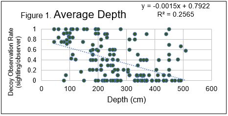
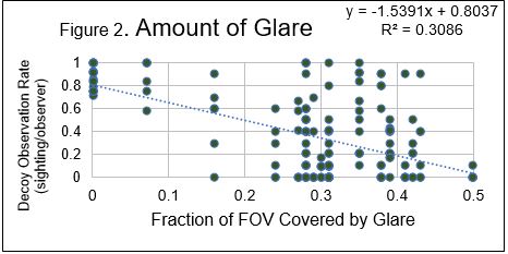
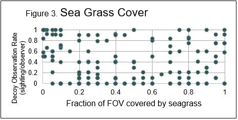
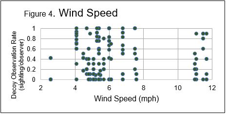
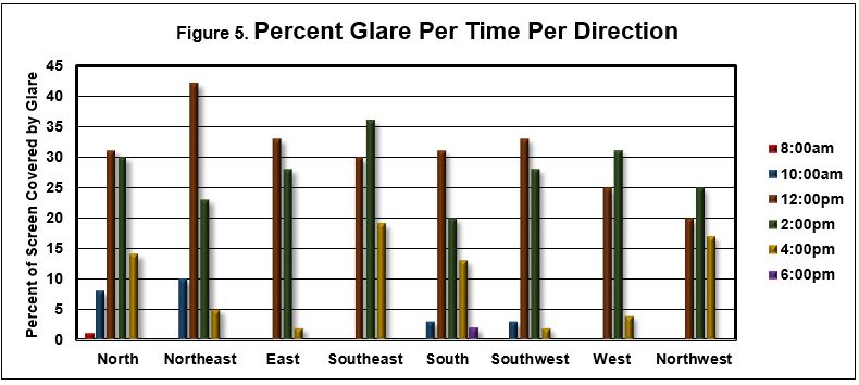
Table 1. Table of models tested for effect on decoy detections and number of times selected using bootstrap samples
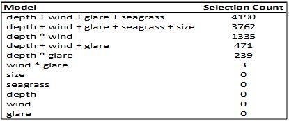
Table 2. Results of best fit generalized linear model. All variables significantly affect detection at an alpha = 0.01. Estimate shows the correlation direction (positive or negative).
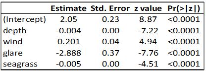
Discussion. The results of this study confirmed the hypothesis, showing that environmental factors can have a profound impact on the accuracy of marine life studies using UAS. The data show that four factors in particular affect the ability to observe sea turtles: sun glare on the surface, water depth, wind, and the amount of sea grass covering the bottom. Glare, sometimes referred to as sun glint, can sometimes mask large areas of the video screen. Strong wind can make flying drones extremely difficult, individual operators must determine whether conditions are suitable for using UAS. Wind also causes surface ripples and wave action, both of which impact visibility. Seagrass beds are a favored habitat for turtles, but from the air, the turtles are camouflaged against the seagrass background. Further data showed the best times and directions to aim the camera to maximize sea turtle visualization: 8:00am facing any direction other than north, and 6:00pm facing any direction other than south. Those times were obtained by flights in the summer in South Florida, so times would have to be chosen to match results in other latitudes and other seasons.
The findings of this study have important global applications. As a threatened species, the green sea turtle needs human attention and intervention to survive in the wild. Research on the habits, abundance, and behaviors of the turtles is vital to inform policy makers on the best strategies to conserve the population of these iconic animals. As more studies are done using UAS surveys, it is imperative that scientists have information at their disposal to make the best use of their time and equipment. This project provides that information and draws attention to potential limitations of this technology that need to be recognized to accurately interpret the data that UAS surveys provide.
Conclusion. Drones are ideal in many ways for studying wildlife, especially because they provide an eavesdropping effect, taking the anthropogenic factor largely out of the equation. Under the right conditions, and with taking appropriate safety precautions, drones can provide up-close, real time study of animals in their native habitats without observer detection. This could revolutionize ecological study by resulting in more accurate observations and significantly reducing the danger of field work for scientists. However, while there are no scientists in the water interfering with turtle behavior, humans still must interpret the images captured on video. Errors in judgement can result in wildlife abundance surveys being inaccurate. This project is exciting because it shows the circumstances under which mistakes are most likely to occur, providing researchers with tools, in the form of information, to avoid missing animals which may be on the video, but hidden by glare or camouflaged against the substrate. The findings of this study are relevant to the accuracy of research that has already been performed, and to future work using drones for ecological studies. This data will contribute to a larger database, and the results could prove vital to our understanding and management of the delicate see turtle habitat. Results from this study and others could lead to legislation aimed at increasing turtle populations, which would have a significant effect on global commercial fishing, shrimp, and tourism industries, and on land development.
Acknowledgements. I would like to thank Elizabeth Whitman, PhD and the Heithaus Lab at Florida International University Biscayne Bay Campus for guiding and mentoring me throughout this research project and for providing me with access to their UAS videos and data. I would also like to thank Miami-Dade County Public Schools Science Division and the Florida State Science and Engineering Fair for acknowledging my work and for providing a venue to present and communicate my research to other scientists.
References
(1) Fuentes, M.M.P.B., Bell, I., Hagihara, R., Hamann, M., Hazel, J., Huth, A., Seminoff, J.A., Sobtzick, S. and Marsh, H., (2015). Improving in-water estimates of marine turtle abundance by adjusting aerial survey counts for perception and availability biases. Journal of Experimental Marine Biology and Ecology, 471, 77-83.
(2) Rees, A.F., Avens, L., Ballorain, K., Bevan, E., Broderick, A.C., Carthy, R.R., Christianen, M.J., Duclos, G., Heithaus, M.R., Johnston, D.W. and Mangel, J.C., (2018). The potential of unmanned aerial systems for sea turtle research and conservation: a review and future directions. Endangered Species Research, 35, 81-100.
(3) Smith, Kurt W. (2015). "Drone Technology: Benefits, Risks, and Legal Considerations," Seattle Journal of Environmental Law: Vol. 5: Iss. 1, Article 12.
(4) Ventura, D., Bonifazi, A., Gravina, M. F., & Ardizzone, G. D. (2017). Unmanned Aerial Systems (UASs) for Environmental Monitoring: A Review with Applications in Coastal Habitats. In: Lopez Mejia OD (ed) In Aerial Robots-Aerodynamics, Control and Applications. InTech. London, p 165−184.
(5) Jones, George Pierce IV, Leonard G. Pearlstine, H. Franklin Percival. (2006). “An Assessment of Small Unmanned Aerial Vehicles for Wildlife Research.” Wildlife Society Bulletin. 34.3:750-758.
(6) Ogden, Lesley Evans. (2013). "Drone ecology." BioScience 63.9: 776-776.
(7) Pereira, E., Bencatel, R., Correia, J., Félix, L., Gonçalves, G., Morgado, J., & Sousa, J. (2009). Unmanned air vehicles for coastal and environmental research. Journal of Coastal Research. 1557-1561.
(8) Chabot, D., & Bird, D. M. (2015). Wildlife research and management methods in the 21st century: Where do unmanned aircraft fit in? Journal of Unmanned Vehicle Systems, 3(4), 137-155.
(9) Duffy, J.P., Cunliffe, A.M., DeBell, L., Sandbrook, C., Wich, S.A., Shutler, J.D., Myers‐Smith, I.H., Varela, M.R. and Anderson, K., (2018). Location, location, location: considerations when using lightweight drones in challenging environments. Remote Sensing in Ecology and Conservation, 4(1), 7-19.

